Jean-François de Galoup.
Noteworthy however is the cartographic trip of the Jean-François
de Galoup, Comte de La Pérouse. Since he was the first who really
used the name "the Sea of Japan" and his example was followed
thereafter, his short biography will follow. He was born on 23 August,
1741 near Albi, France. He entered the Navy when he was fifteen, and
fought the British off North America in the Seven Years' War. Later
he served in North America, India and China. In August 1782 he made
fame by capturing two English forts on the coast of the Hudson Bay.
The next year his family finally consented to his marriage to Louise-Eléonore
Broudou, a young Creole from modest origins he had met on Ile de France
(present-day Mauritius). He was appointed in 1785 to lead an expedition
to the Pacific. His ships were the Astrolabe and the Boussole, both
500 tons. They were storeships, reclassified as frigates for the occasion.
La Pérouse was a great admirer of James Cook, tried to get on well
with the Pacific islanders, and was well-liked by his men. Among his
114 man of crew there was a large staff of scientists: An astronomer,
a physicist, three naturalists, a mathematician, three draftsmen,
and even both chaplains were scientifically schooled.
He left Brest on August 1785, rounded Cape Horn, investigated the
Spanish colonial government in Chile, and by way of Easter Island
and Hawaii he sailed to Alaska, where he landed near Mount St. Elias,
in late June 1786 and explored the environments. A barge and two longboats,
carrying 21 men, were lost in the heavy currents of the bay they arrived
in (called Port des Français by La Pérouse, but now known as Lituya
Bay). Next he visited Monterey, where he examined the Spanish settlements
and made critical notes on the treatment of the Indians in the Franciscan
missions.
He crossed the ocean to Macao, where he sold the furs acquired in
Alaska, dividing the profits among his men. The next year, after a
visit to Manila, he set out for the northeast Asian coasts. He saw
Quelpaert Island (Cheju) on May 21, 1787, (see map of Quelpaert)
He saw the island of Ullûng-do on May 27 and called it Dagelet
after an astronomer who sighted it. He wrote the following:
"We sighted it on May 21 in the finest weather imaginable and
in most favorable conditions for observations. I coasted along the
southeast shore at a distance of leagues and we surveyed with the
utmost care a length of 12 leagues. One would be hard put to find
a more pleasing prospect. ... The various crops which presented a
wide range of colors made the appearance of this island even more
pleasing,"
However, he did not anchor on the island where the Dutch castaways
were shipwrecked in 1653, worrying for the safety of his crew members.
"Unhappily, it belongs to people who are forbidden to communicate
with strangers and who currently enslave those unfortunate enough
to be shipwrecked on their coast. This story, of which we had an account
before us was not of a nature to encourage us to send a boat ashore,"
adding that their appearance caused some alarm among the locals, who
began to light signal fires on all the headlands along the coasts.
They spotted the present Ullûng-do in the East Sea (which he
called for unknown reasons, the Sea of Japan) and some of its inhabitants
on May 27. The crew wanted to set foot on the new found island, with
the good intention of making friends with the locals who ran away
at the sight of the foreign vessels.
"I endeavored to approach it but it was exactly in the wind's
eye; fortunately it changed during the night and at daybreak I sailed
to examine this island, I was very desirous of finding an anchorage
to persuade these people by means of gifts that we were not their
enemies, but fairly strong currents were bearing us away from the
land."
The French navigators then crossed over to Oku-Yeso (Sakhalin). La
Pérouse was enthusiastic about the people of Sakhalin and their friendliness:
"Since leaving France, we had not encountered others, who so
excited our interest and admiration... It went against our preconceived
ideas to find among a hunting and fishing people, who neither cultivated
the earth nor raised domestic animals, manners which were in general
more gentle and grave -and who perhaps had greater intelligence- than
that to be found in any European nation."
The inhabitants had drawn him a map, showing their country, Yeso (also
Yezo, now called Hokkaido) and the coasts of Tartary (mainland Asia).
La Pérouse wanted to sail through the channel between Sakhalin and
Asia, but failed, so he turned south, and sailed through La Pérouse
Strait (between Sakhalin and Hokkaido), where he met the Ainu, explored
the Kuriles, and reached Petropavlovsk (on Kamchatka peninsula) in
September 1787. Here they rested from their trip, and enjoyed the
hospitality of the Russians and Kamchatkans. In letters received from
Paris he was ordered to investigate the settlement the British were
to erect in New South Wales. Barthélemy de Lesseps, the French vice
consul at Kronstadt, who had joined the expedition as an interpreter,
disembarked to bring the expedition's letters and documents to France,
which he reached after a one year lasting, epic journey across Siberia
and Russia.
His next stop were the Navigator Islands (Samoa). Just before he left,
the Samoans attacked a group of his men, killing twelve of them, among
which de Langle, commander of the Astrolabe. He then sailed to Botany
Bay, arriving on 26 January 1788, just as Captain Arthur Phillip moved
the colony from Botany Bay to Port Jackson. The British received him
courteously, but were unable to help him with food as they had none
to spare. La Pérouse sent his journals and letters to Europe with
a British ship, obtained wood and fresh water, and left for New Caledonia,
Santa Cruz, the Solomons, the Louisiades, and the
western and southern coasts of Australia. He nor any of his men was
seen again.
In 1791-1793 Antoine de Bruni, chevalier d'Entrecasteaux looked for
La Pérouse, but found no trace of him, and it was not until 1826 that
an English captain, Peter Dillon, found evidence of the tragedy. In
Tikopia (one of the islands of Santa Cruz), he bought some swords
of which he had reason to believe had belonged to La Pérouse. He made
inquiries, and found that they came from nearby Vanikoro, where two
big ships had broken up. Dillon managed to obtain a ship in Bengal,
and sailed for
Vanikoro where he found cannon balls, anchors and other evidence of
the remains of ships in water between coral reefs. He brought several
of these artifacts back to Europe, as did D'Urville in 1828. De Lesseps,
the only member of the expedition still alive at the time, identified
them, as all belonging to the Astrolabe. From the information Dillon
received from the people on Vanikoro, a rough reconstruction could
be made of the disaster that struck La Pérouse, which was confirmed
by the find and search of the shipwreck of the Boussole in 1964.
Both ships had been wrecked on the reefs, the Boussole first. The
Astrolabe was unloaded and taken apart. A group of men, probably the
survivors of the Boussole were massacred by the local inhabitants.
Others built a small boat from the wreckage of the Astrolabe, and
left westward about 9 months later. Apparently this boat shipwrecked
somewhere, possibly in the Solomon Islands.
The map below shows the map La Pérouse made of Cheju-do, the general
coast line is not very accurate and the islands are drawn with quite
some fantasy. There are no city names shown, nor any indication where
harbors were. The scale is interesting though since the on the map
nautical miles are mentioned, there were 20 nautical miles in a degree,
which makes a nautical mile (Lieu Marine) 5600 meter. 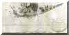 The
south point's latitude is accurate, though the longitude mentioned
is about 250 km too much west. However when one looks at the meridian
of Paris (which is probably used by La Pérouse, since no self respecting
17th century French cartographer would use the Greenwich meridian),
then again it's pretty accurate. The island of Kapado is recognizable
but it is drawn west of the peninsula Songaksan, instead of south
of it. Even on a distance of 10 km, one can see those details, so
one can start to wonder if they really saw the island or made the
map on the oral account from somebody else. On the same map (this
is just an out-cut) one can find Dagelet or Ullûng-do The
south point's latitude is accurate, though the longitude mentioned
is about 250 km too much west. However when one looks at the meridian
of Paris (which is probably used by La Pérouse, since no self respecting
17th century French cartographer would use the Greenwich meridian),
then again it's pretty accurate. The island of Kapado is recognizable
but it is drawn west of the peninsula Songaksan, instead of south
of it. Even on a distance of 10 km, one can see those details, so
one can start to wonder if they really saw the island or made the
map on the oral account from somebody else. On the same map (this
is just an out-cut) one can find Dagelet or Ullûng-do
In the remainder of this article a number of maps with a short description
will be shown.
|