Hendrick Hamel.
The shape of and information about Korea change drastically, when
Hendrick Hamel and his companions returned from their adventures on
the Korean peninsula. The Sperwer, with sixty-four men on board left
Batavia on June 18 1653. On August 16 1653, the Sperwer was lost in
a storm and twenty-eight men perished. Thirty-six survivors, driven
ashore on the western coast of Cheju Island, were all interned and
spent ten months on the island. One of their biggest surprise was
their encounter with their contemporary Jan, Janse Weltevree, a Dutchman
in the service of the Korean king. They were transferred to Seoul
where they were employed as bodyguards to a general for about three
years. They appealed to the King to release them but they were always
told that it was not his policy to send foreigners away from his land.
The King apparently did not want facts about his country to become
known to other nations. Then, when a Manchu envoy came to Seoul, the
senior navigator and one sailor approached him in an attempt to return
to the Holland by way of China , they were immediately captured and
jailed. After this incident, the remaining thirty-four Dutch sailors
were transferred to Pyongyong, an army camp near Kangjin in Cholla
province.
They lived seven years in Pyongyong and eleven of them died during
that period. After three successive famines in 1660, 1661 and 1662,
they were divided into three groups since Pyongyong could hardly afford
to support them and were sent to Saesong (12 men), Sunchon (5 men)
and Namwon (5 men). At the time of their escape attempt, sixteen men
were still alive, of whom eight succeeded in reaching Nagasaki. In
his section, "Description of the Kingdom of Korea" Hamel's
observations on a wide range of subjects with which he came into contact
or which caught his observant eye, are described. Hamel examined Korean
life and customs from the perspective of his own cultural background,
Holland and Western civilization in the seventeenth century. Hamel
could make observations at close hand because the Dutch sailors were
allowed to go about relatively freely with few restrictions. Moreover,
Hamel could observe the lifestyle of upper class people because curiosity
prompted these people to invite the Dutch to their homes. Many of
Hamel's observations are verifiable either by the looking at established
historical facts or observing customs which still survive from former
times. (more about the adventures of Hendrick Hamel can be found on
the Internet at http://www.henny-savenije.pe.kr
where one can find an English and Korean translation of the manuscript
and all the 17th-century documents relating to this event and his
original manuscript)
When 8 of the 16 escaped, the Heeren XVII (the board of directors
of the VOC) were of course interested in possible mercantile contacts
with Korea and Hendrick was asked to write down his report by the
opperhooft (chief) of the factory in Deshima. For about 200 years
this was basically the only information which was available about
Korea, and reprinted in many different ways (upon his arrival back
in Holland, it was printed already by 3 different Dutch publishers!)
while every publisher and translator added his own distortions and
fantasies, sometimes to make it more attractive to their readers.
But when one goes back to the original manuscript his report appears
to be as accurate as possible under the circumstances. He also uses
native resources when he mentions the distances from Pusan to Shimonoseki
(which has been read by his publishers for a long time as Osaka),
but also the length and width of Korea. He uses the "dietse mijl"
(Dutch mile) which caused a lot of confusion in translations in later
times, since they were translated as German miles, leagues and other
contemporary distance measurements. Using these contemporary measures,
Dutch cartographers could make accurate measurements.
Hamel already said that the Koreans themselves made maps with Korea
shown like an oblong. Though Hamel made no maps himself, his descriptions
of the country influenced cartographers. Hamel landed on Cheju-do
which appeared on Portuguese maps before as Ilha de Ladrones (island
of thieves), but also the Mariana Islands were referred to as the
Ladrones.
Interesting in this regard is the fact that Cheju island existed
with two different names and was thought to be two islands as well:
Fung-ma and Quelpaert island. Quelpaert is probably named after a
type of galleon. Though there is no reference to this type of ship
other than in the documents from Batavia found in the VOC archives.
Unfortunately we will never know for sure, but probably it was the
result of a copying error in a document to the east and therefore
this type of ship was only known in the east.
Cheju-do was doomed to be called Quelpaert island for the next two
centuries thanks to Hamel's document. The Dutch cartography however
was already in decline and the Hamel type never made it to the Dutch
maps. Due to the fact that he was the first westerner to write an
account of Korea, Hamel is called the "discoverer" of Korea.
In connection with Hamel I have to mention briefly Nicolaas Witsen
(1641-1717). He provides us with much interesting information about
Korea in his "Noord en Oost Tartaryen", the second edition.
Witsen, whose motto was Labor omnia vincit, was the scion of a prominent
and wealthy family in Amsterdam. He studied law, philology, mathematics
and astronomy at Leyden University where he took his L.L.D. in 1664.
He also applied himself to the study of geography, cartography and
hydraulic engineering. He was an able etcher and became a specialist
in shipbuilding. In 1697 - 98 he taught this art to Czar Peter the
Great who was then studying in the Netherlands. Between 1682 and 1705
he was thirteen times mayor of Amsterdam; he represented that city
nearly continuously in the States of Holland and the States General
of the Netherlands. As a young man he had also served his country
as a diplomat in Moscow."  For
his description of Korea Witsen made use of the following sources:
Martini , Martino, Novus atlas sinensis, Amsterdam 1655; Montanus
, Arnoldus, Gedenkwaerdige Gezantschappen aen de Kaisaren van Japan
(Memorable Envoys to the Emperors, i.e. Shogun, of Japan), Amsterdam
1669; a report of a court journey (Nagasaki-Edo) made by the Dutch
in 1637; a description of Korea by a "certain Slavonic (i.e.
Russian) author"; information provided by Anreas Cleyer, chief
merchant at Dejima in 1683 and 1686; "a" report from Japan
and the account of Hamel's shipwreck. Eye-witness information was
furnished by Benedictus Klerk and Master Mattheus Eibokken , two of
Hamel's companions-in-distress. Remarkable is the list with Korean
words Witsen provides (can be found on my website).
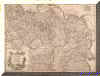
In his first (unpublished) edition he had a remarkable image of Korea.
See a detail of his Nova Tabula Imperii Russici below: It was supervised
by Everardus Ysbrants Ides. Amsterdam. On this map we find Corea,
Chausin (=Choson) with Japan in the middle. This map is unique but
nevertheless a type: the Witsen-type. For
his description of Korea Witsen made use of the following sources:
Martini , Martino, Novus atlas sinensis, Amsterdam 1655; Montanus
, Arnoldus, Gedenkwaerdige Gezantschappen aen de Kaisaren van Japan
(Memorable Envoys to the Emperors, i.e. Shogun, of Japan), Amsterdam
1669; a report of a court journey (Nagasaki-Edo) made by the Dutch
in 1637; a description of Korea by a "certain Slavonic (i.e.
Russian) author"; information provided by Anreas Cleyer, chief
merchant at Dejima in 1683 and 1686; "a" report from Japan
and the account of Hamel's shipwreck. Eye-witness information was
furnished by Benedictus Klerk and Master Mattheus Eibokken , two of
Hamel's companions-in-distress. Remarkable is the list with Korean
words Witsen provides (can be found on my website).
In his first (unpublished) edition he had a remarkable image of Korea.
See a detail of his Nova Tabula Imperii Russici below: It was supervised
by Everardus Ysbrants Ides. Amsterdam. On this map we find Corea,
Chausin (=Choson) with Japan in the middle. This map is unique but
nevertheless a type: the Witsen-type.
In the second edition he uses the Martini type.
 The
text in the cartouche of the following map has the following content:
corrected from the observation communicated to the Royal Society at
London and the Royal Academy at Paris / by John Senex, FRS, at the
Globe against Dunstans Church, Fleet Street in London (67cm x 99cm)
-- [early 18th Century] 134 Hamel-type The
text in the cartouche of the following map has the following content:
corrected from the observation communicated to the Royal Society at
London and the Royal Academy at Paris / by John Senex, FRS, at the
Globe against Dunstans Church, Fleet Street in London (67cm x 99cm)
-- [early 18th Century] 134 Hamel-type
 The
cartouche on this map contains the following text: Carte de Tartarie,
dressee sur les relations de plusieurs voyageurs de differentes nations
et sur quelques observations qui ont ete faites dans ce pais la, par
Guillaume De l'Isle, premier geog. du Roy de l'Academie Royale des
Sciences, a Paris chez l'auteur sur le quai de l'Horloge a l'Aigle
d'Or avec privilege, 1706. (51cm x 67.5cm) Hamel-type The
cartouche on this map contains the following text: Carte de Tartarie,
dressee sur les relations de plusieurs voyageurs de differentes nations
et sur quelques observations qui ont ete faites dans ce pais la, par
Guillaume De l'Isle, premier geog. du Roy de l'Academie Royale des
Sciences, a Paris chez l'auteur sur le quai de l'Horloge a l'Aigle
d'Or avec privilege, 1706. (51cm x 67.5cm) Hamel-type
 A
similar map, but now a detail also from the De l'Isle this is a pure "Hamel" map,
though the French transcription of Chinese characters are used: A
similar map, but now a detail also from the De l'Isle this is a pure "Hamel" map,
though the French transcription of Chinese characters are used:
After the death of Johannes Janssonius (1664) and Joan Blaeu (1672)
the business in Holland shifted to other people since their descendents
were not as proactive as their parents. The trade was dominated by
5 firms at that time: Nicolaes Visscher I and II, the Danckerts family,
Frederick de Wit, Carel Allard and Petrus Schenk together with Gerard
Valk. They all produced almost identical products, wall maps and
atlas maps. They also sold atlases which they compiled from their
own or other's maps. More original work was provided by Pieter van
der Aa in Leiden and Pieter Mortier who was the first one to bring
a renewal in Dutch map production.
Nicolaes Visscher I and II
The map trade of the Visscher family had its roots in the early 17th century.
Claes Jansz. Visscher (1587-1652) acquired a high reputation as an engraver and
etcher of prints and maps. His successors, his son Nicolaes Visscher (1618-1679)
and grandson Nicolaes Visscher II (1649-1702) practiced the map trade on a large
scale. The Visschers produced a total of over 260 Atlas maps. They compiled their
Atlases using dozens of maps from other publishers. After the death of Elisabeth
Verseyl, the widow of Nicolaes Visscher II , the copper plates passed in 1726
into the hands of Petrus Schenk II who used them for several reprints.
The Danckerts family
Many members of the Danckerts family worked as engravers and map resellers. The
most important were Justus Dankerts (1635-1701) and his two sons Theodorus (1663-1727)
and Cornelis (1664-1717). They owned the copper plates of Plancius' famous wall
map in two hemispheres of 1607, which they used to make a reprint in as late
as 1676. Justus placed a title page at the front of his atlases, simply stating
Atlas.
Frederick de Wit
Frederick de Wit (1630-1706) was one of the most active map sellers in the second
half of the 17th century. He himself also being an engraver. His oldest known
maps date from around 1660. He published about 130 charts and 27 maps himself,
but he also had at his disposal copper plates from the town books of Blaeu and
Jansonius. De Wit sold five kinds of atlases; i.e. world atlases with the title
Atlas and Atlas Major (containing 17 to 190 maps) a marine atlas of 27 maps,
an atlas of the Netherlands containing 20-25 maps, and the town books of the
Netherlands (124 or 128 town plans and town views) and of Europe (128 sheets).
the last two compiled from Blaeu's and Jansonius' copper plates. His stock of
maps and copper plates was bought by Pieter Mortier in the spring of 1710.
Carel Allard.
Carel Allard (1648-1706) was the son of Huych Allard (died 1691), who sold maps
in the Kalverstraat (the main street of Amsterdam) from 1645. Carel Allard compiled
a few atlases with a reasonably homogeneous content, one of 521 maps which he
called Atlas Major, as well as atlases of 100, 105, 110, 150, or 260 maps, wihch
were all called Atlas Minor. They contained maps not only from Allard's own publishing
house, but also made by Blaeu, Janssonius, De Wit and Visscher. During the period
1680-1700 they produced a number of new, highly decorative maps intended to replace
the out of date maps of Blaue and Janssonius in their atlases.
A large portion of Allard's copperplates passed to Pieter Mortier in 1708.
Petrus Schenk and Gerard Valk
The Valk and Schenk families were closely interrelated. Petrus Schenk (1660-1711)
was married to the sister of Gerard Valk (1652-1726), while Gerard's son Leonardus
Valk (1675-1746) married his cousin Maria Schenck, the daughter of Petrus. Gerard
Valk and Petrus Schenk collaborated from about 1680. In 1694 they obtained the
copper plates from Johannes Janssonius' atlas maps, which were publicitly sold
amont the booksellers by the heirs of Janssonius' son. They used those plates
to produce a new edition of the Novus Atlas, including the celestial atlas of
Cellarius. In 1695 they started to publish copies of the French maps of Samson.
Gerard Valk and his son Leonard were mainly famous after 1700 for their new globes.
Petrus Schenk did not take part in his brother in law's globe venture. He started
on the production of maps and an atals of the war zones. Petrus Schenk's map
business was continued after his death by his son Petrus II Schenk (1693-1775)
and grandson Petrus Schenk jr. (1728-1803). The Schenk scarcely produced any
original work.
Pieter Mortier
Pieter Mortier (1661-1711) set the trend of selling maps of French origin. He
himself was originally French and established himself on the Vijgendam in Amsterdam
in 1865 as a bookseller in De stad Parijs (the city of Paris). He had lived in
Paris from 1681 to around 1685 and learned the bookseller's trade there. With
the good relations he had with France and the improvement of the map-production
there, he realized that the publication of old Dutch maps would not be lucrative
in the long run. Transport problems and the capacity of the French printers led
him to decide not to sell the copies printed in Paris, but to have them re-engraved
in Amsterdam and print them himself. On 15 September 1690 he obtained the privilege
from the States of Holland and Westfriesland, granting him the sole right to
publish the maps of the French geographer Nicolas Sanson (1600-1667) and publisher
Alexis Hubert Jaillot (1632-1712) in the Netherlands for 15 years. He also copied
the marine Atlas Le Neptune Francois published in 1693 and embellished it with
the impress of Jaillot who never published the atlas himself!
In the early 18th century he bought all the old copperplates and in the course
of a few years he managed to buy all the copperplates of the other Amsterdam
map dealers. He found that the public not only valued the highly decorative older
but obsolete maps but collectors started to outdo each other and they didn't
care if a map was up-to-date or obsolete. IN 1704-1705 he reprinted Blaue's town
books and atlases. On 7 August 1708 over 1600 lots of maps and atlases of Carel
Allard were publicly sold and he bought them all. In March 1710 he bought the
copperplates and stock of Fredrick de Wit's world atlas and he reprinted the
complete atlas with his own imprint. He advertised the maps of the French Geographer
Guillaume de l'Isle (1675-1725) but also continued to print the maps and atlases
of the older French and Dutch geographers. He died in 1711 and his book and map
business was continued by his widow and his son Cornelis Mortier (1699-1783)
after her death in 1719. That he was a successful businessman shows the total
value of the widow's estate: 364 000 guilders which was a fortune in those days.
Obviously the son was not capable of continuing his father's business and established
a partnersship with his brother in law Johannes Covens (1697-1774) who was responsible
for the financial managerial part and they dominated with little original material
the 18th century Dutch map trade.
Pieter van der Aa
Pieter van der Aa (1659-1733) occupied a remarkable position in the Dutch map
production. Not only because he was active in Leiden and not in Amsterdam but
also because of the enormous volume of his own production. In contrast with his
Amsterdam colleagues van der Aa had not gained possession of the copperplates
from Blaeu or Janssonius. He therefore published enormous multi-part geographical
works. The Naaukeurige versameling der gedenkwaardigste zee- en land-reysen,
which was published between 1706 and 1708 comprised 28 parts. In 1729 he completed
the Galerie agreable du monde in 66 parts contining over 3000 maps, town plans
and topographic prints. It was the largest picture and map book ever published.
Not all the plates were his own. That was too much, even for van der Aa.
Besides these gigantic picture books, Pieter van der Aa compiled a number of
atlases. For these he used maps from his Naaukeurige verzameling.
|